Liveuamap
- 3.0
- Rating
- 1.00M
- Installs
- Free
- Price

 Analysis by App-foxy
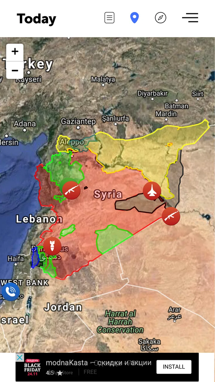
I found Liveuamap most useful when I stopped treating it like a normal headline reader. It is a news and magazines app built around a map, so the main question is not simply “what happened today?” but “where is something happening, and how does it relate to nearby events?” That change in viewpoint makes it interesting for following fast-moving situations, regional developments, and stories that are difficult to understand when they are presented as an endless list.
In my experience, the app works best as a visual starting point. I open the map, look for clusters of markers, select an event that catches my attention, and then use the linked information to decide whether I need to investigate further. It is not a replacement for careful reporting, and I would not use a single map entry as the only basis for an important conclusion. Still, the geographical layout can reveal patterns that a conventional news app makes easy to miss.
How I use Liveuamap without getting lost in the map
I use the map most confidently when I decide what I’m trying to learn before I start moving around: a local update, a regional pattern, or a quick check on a story I already follow. That small choice gives each scan a stopping point and helps me avoid mistaking a busy screen for a complete picture. Next, I look at a few practical checks that can make those focused sessions easier to manage.
You May Also Like

 Blood Strike: 2.5 Anniversary
Blood Strike’s Loadouts Turn Every Drop Into a Tactical Gamble
A close look at Blood Strike’s custom loadouts: how fast access to signature weapons reshapes its battle royale rhythm, rewards preparation, and narrows the gap between fights.

 Pandora - Music & Podcasts
Pandora’s Music Is Easy to Start, but Harder to Recover
Pandora’s strength is its low-effort path from a seed to a station. Its weak spot is how much confidence it asks you to place in connection, setup, and quiet recovery.

 8 Ball Pool
 Is Built on Rivalries, Rematches, and Routine
A close look at the rivalries, rematches, shared routines, and unanswered safety questions that turn a quick pool match into a persistent mobile community.

 Samsung Music
’s Quiet Strength Is Playing What You Already Own
Its reach comes less from spectacle than from dependable access to a personal library. That simplicity is both the app’s strongest retention engine and its ceiling.

 AccuWeather: Weather Radar
AccuWeather Review: A Quick, Clear Forecast for Everyday Decisions
For everyday plans, the best forecast is the one you can understand quickly. AccuWeather makes rain timing, radar, and local conditions easy to act on, with a few trade-offs.

 Hill Climb Racing
Why Hill Climb Racing Still Turns Crashes Into One More Run
A tiny car, a bumpy hill and one more upgrade: Hill Climb Racing keeps resurfacing because its simple chaos makes every near-miss feel personal.
More From Our News Desk



A practical baseline workflow
My usual routine begins with a quick scan rather than opening every marker. A crowded map can be visually persuasive, but density alone does not tell me which event matters most. I first identify the area I care about, zoom in gradually, and choose a small number of markers that appear relevant to the same developing story. This keeps the session focused and prevents the app from turning into a stream of disconnected alerts.
After opening an event, I pay attention to its location, timing, and relationship to nearby entries. A marker becomes more useful when it can be placed beside other events in the same area. For example, if I am checking a region during a busy news cycle, I can compare incidents across neighboring places instead of reading each item as an isolated headline. The map is strongest as a context tool, not as a complete newsroom.
I also avoid making the first marker I see the center of my understanding. Map-based news encourages quick reactions because the visual layout feels immediate. My habit is to open several related entries, note whether they describe the same broader development, and then consult broader reporting when the subject is sensitive or consequential. That extra step matters because a location marker can show where an event was reported without explaining every part of what happened.
For everyday use, this workflow is more manageable than constantly refreshing a general news feed. I can check a region, gather a rough picture, and leave. When I return later, the map gives me a visual reminder of the areas that deserve another look. People who want a single polished article with background, interviews, and extensive explanation may find a traditional news publication more satisfying, but readers who think geographically will probably understand the appeal quickly.
A realistic daily scenario
Imagine that I am following news from a country where several cities are appearing in the headlines. In a standard feed, I might see articles arranged by publication time, with no obvious sense of distance between them. In Liveuamap, I can begin with the country or region, inspect the markers around each city, and compare the locations before deciding what to read in detail.
That is especially helpful when I am trying to answer a practical question such as whether an event is isolated or part of a wider sequence. I can zoom out to see the broader distribution, then zoom back in to inspect a particular area. I would still verify major claims through reliable reporting, but the map gives me a faster way to organize my attention. It reduces the time spent guessing which stories belong together.
Another useful situation is travel planning during an unsettled news period. I would not treat the app as an official safety service, but I could use it to become aware of developments near a route or destination and then check government guidance and trusted local sources. That distinction is important: Liveuamap can help me notice a situation, while a dedicated authority should guide decisions about safety, movement, or emergency action.
Settings I would check first
The first settings-related habit I recommend is simple: make the visible area match the question you are asking. If I am researching one region, I do not leave the map at a scale that shows too much of the world. If I am looking for a wider pattern, I zoom out only after understanding the local entries. This is not a flashy trick, but it makes the app much less noisy.
I would also review any available display or notification choices before using the app regularly. The right setup depends on how I want to follow news. Someone who checks manually may prefer a quieter experience, while someone tracking a rapidly changing situation may want timely updates. I would be careful not to enable every possible interruption simply because the subject is important; too many alerts can make it harder to distinguish meaningful developments from routine activity.
Because the app is free to download, it is easy to install it casually and forget to adjust the way it fits into a daily routine. I think it works better when I decide in advance whether I am using it for a short morning scan, a focused regional check, or active monitoring during a major story. That decision affects how much map detail I need and how often I return.
The app is rated for Everyone 10+, which makes it broadly approachable, but that does not mean every mapped subject will feel comfortable for every reader. News about conflict, disasters, or violence can be upsetting. I would not hand it to a young user without considering the material they may encounter, even though the formal age guidance is relatively inclusive.
Faster patterns for experienced users
Once I became familiar with the map, I developed a repeatable three-pass method. The first pass is wide: I look at the whole area to identify clusters. The second is narrow: I zoom into the cluster that appears relevant and open only a few representative entries. The third is comparative: I return to the wider view and ask whether the local story connects to activity elsewhere. This pattern is faster than opening markers at random.
A second useful habit is to separate discovery from verification. During discovery, I use the map freely and accept that some entries will be incomplete for my purposes. During verification, I stop browsing and check the most important details through dependable sources. Mixing those tasks can lead me to confuse an interesting marker with a confirmed account. Keeping them separate makes the app more valuable and keeps my expectations realistic.
I also find it helpful to keep a short mental or written list of the places I revisit most. Rather than trying to absorb the entire map, I compare the same areas over time. This turns the app from a one-off curiosity into a monitoring tool. The trade-off is that I may miss an unrelated story elsewhere, so I occasionally reset my view and perform a broader scan.
When I am reading on a small phone screen, I use deliberate zoom changes instead of dragging quickly across the map. Fast movement can make it easy to skip a marker or lose the area I was examining. A slower approach feels less exciting, but it is more accurate. On a larger screen, the geographic concept is easier to appreciate because I can retain more surrounding context while inspecting an individual entry.
Another practical tip is to avoid judging importance by marker count. A heavily covered location may reflect repeated reporting, while a single marker may represent a major development. The app helps me see where activity is being reported; it does not automatically rank the significance of each event for my personal needs. That is where editorial judgment and outside reading remain necessary.
Where it differs from ordinary news apps
Most news apps organize information by publication, topic, popularity, or time. Those systems are convenient when I already know what I want to read. Liveuamap takes the opposite route: place comes first. That makes it particularly useful when my question begins with “what is happening in this area?” rather than “what are the biggest stories today?”
The map also changes how I notice connections. A list may place two related events far apart because they were published at different times or by different sources. A geographic interface puts them within the same visual frame. This is the app’s clearest advantage, and it is why I would keep it alongside, rather than instead of, a conventional news reader.
There are trade-offs. A standard publication usually provides a clearer editorial voice, more polished explanations, and a stronger distinction between a developing report and a finished article. Liveuamap can feel more immediate, but that immediacy may require more work from me. I have to interpret the map, follow the available information, and decide what deserves confirmation.
It is also less suitable for relaxed reading. If I want a carefully edited morning briefing, a newspaper app or magazine app is probably better. If I want to understand how events are distributed across a region, this app offers a perspective those alternatives often lack. The best setup for me is to use Liveuamap for orientation and traditional reporting for depth.
Advanced limits I keep in mind
The biggest limitation is that a map can create an impression of precision. A pin looks exact, yet the visual placement does not necessarily answer every question about the event, its source, or its reliability. I treat the location as useful context, not as proof that I understand the full situation. This is particularly important with fast-moving or politically sensitive news.
Another limitation is cognitive overload. A map filled with markers may look informative while becoming difficult to process. I get better results when I narrow my purpose: one country, one region, one developing story, or one time window. Trying to monitor everything at once is not a sign of advanced use; it usually produces shallow attention.
I would also be cautious about using the app as my only source during an emergency. It can help me identify what to investigate, but official instructions, local authorities, emergency services, and established reporting should take priority when decisions carry real consequences. The app is a useful layer in an information workflow, not a substitute for direct guidance.
Performance expectations should be realistic as well. A map interface naturally asks me to pan, zoom, and inspect multiple items, so it can feel more demanding than scrolling through headlines. On a phone, the experience depends heavily on how much detail is visible at once. I find it most comfortable when I accept that the app is for deliberate exploration rather than effortless passive consumption.
Version, cost, and what the numbers suggest
Liveuamap comes from Altwork and has been available since December 15, 2014. Its current version is 3.0.58, and it requires Android 6.0 or later. That long presence suggests a product with a clear identity rather than a temporary experiment, although longevity alone does not guarantee that every part of the interface will feel modern.
The app is free, with optional in-app purchases ranging from $1.99 to $4.49 per item. I would start with the free experience and decide only afterward whether any paid option genuinely improves my routine. Since the core appeal is the map-based way of organizing news, I would not pay simply because I enjoy the concept; I would pay only if an option removes a real friction point for the way I follow events.
It has passed one million installs, while its average rating is 3.0 from around 4.9 thousand ratings. I read that combination as a reason to try it personally rather than relying on popularity. Many people clearly find the idea useful enough to install, but the middling score also fits my impression that map-based news requires patience and may not suit everyone.
Who should use it, and who should skip it
I recommend giving Liveuamap a try if you follow international news, monitor a particular region, work with location-based information, or learn better when events are arranged spatially. It is also a good companion for readers who feel that ordinary feeds hide relationships between nearby incidents. The app rewards curiosity and a willingness to compare locations.
I would skip it if I want a calm, fully edited news digest with clear background in every item. I would also avoid depending on it alone for emergency decisions, professional verification, or detailed investigative understanding. Readers who dislike maps, markers, and self-directed browsing may find the interface more tiring than helpful.
For me, the deciding question is whether geography changes the way I understand a story. If the answer is yes, Liveuamap adds something meaningful to my news routine. If I only want headlines and finished articles, another news app is likely to be more efficient.
My final assessment after building a routine
Liveuamap is worth keeping as a second news window, not treating as my entire news diet. Its map-first design gives me a quick way to see where activity is concentrated, compare nearby events, and choose what deserves deeper reading. The experience becomes noticeably better when I use a consistent zoom-and-check routine, limit the area I am studying, and separate discovery from verification.
The app’s weaknesses are closely tied to its strengths. It feels immediate because it is not simply a polished stream of finished stories, but that means I must supply more judgment. It can reveal geographic context quickly, but the visual presentation can tempt me to assume more certainty than the map itself provides. I appreciate the perspective, while keeping traditional reporting and official guidance in the workflow.
After trying it in that role, I see why it has attracted more than one million installs despite an average score of 3.0. The concept is distinctive, and it can become genuinely useful for the right reader. My recommendation is straightforward: install it if you want to follow news by place, begin with short focused sessions, adjust the experience to avoid unnecessary noise, and use it as a smart discovery layer beside—not instead of—careful journalism.
FAQs for Liveuamap
01What is Liveuamap and how does it work?
Liveuamap is a real-time map application that provides users with the latest news and events from around the world. It aggregates data from various sources, including social media, news outlets, and direct reports, to display incidents on an interactive map. Users can filter information by categories such as conflicts, protests, and natural disasters.
02Is Liveuamap available for both Android and iOS?
Yes, Liveuamap is available for download on both Android and iOS platforms. Users can access the app through the Google Play Store for Android devices and the Apple App Store for iOS devices. The app is compatible with most smartphones and tablets, providing a seamless experience across devices.
03Does Liveuamap offer real-time updates?
Liveuamap provides real-time updates by continuously aggregating data from multiple sources. Users can see the latest developments as they happen, with new incidents appearing on the map instantly. This feature ensures that users stay informed about global events as they unfold, making it a reliable source for current news.
04Are there any costs associated with using Liveuamap?
Liveuamap offers a free version with basic features accessible to all users. However, there may be premium options available for those who wish to access additional features or remove ads. These premium options usually require a subscription fee, which helps support the app's development and maintenance.
05How does Liveuamap ensure the accuracy of its information?
Liveuamap relies on a combination of automated data aggregation and human verification to ensure the accuracy of the information displayed. The app sources data from reputable news outlets and social media, and cross-references reports to confirm their validity. This process helps maintain a high level of reliability and trustworthiness for users.
Pros
- Real-time updates on global events
- Interactive map with detailed info
- Customizable notifications
- User-friendly interface
- Wide coverage of diverse topics
Cons
- Limited offline access
- Ads can be distracting
- Some areas lack detailed coverage
- Occasional loading delays
- Subscription needed for premium features

Liveuamap
Gallery